2017
-
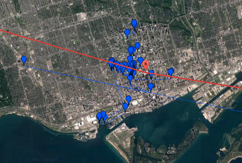
In the first parts of this series we saw a basic, embedded map and then added information windows and labels. In this post we're going to overlay data being recorded by a tracking device to show our progress in real-time. This was made pretty easy thanks to Garmin's MapShare service: our Iridium-connected inReach Explorer+ device publishes tracking information automagically to our MapShare page, which has a KML feed that can be embedded as an overlay on Google Maps. The additional code, below, is trivial. It's possible to zoom into the location of the latest data on map load, but I've…
-
Several people have looked at our trip's itinerary and have reacted in a similar way: Washington DC New York West Hartford Toronto … "Wait a minute… why on earth are you going to West Hartford?" It boils down to this: one of my closest friends lives there. Duncan and I met during our first week or so at University – we played field hockey together – and ended up becoming very good friends: we lived in a shared house during our 2nd year at Uni, for instance. We've stayed in touch ever since, visiting each other in the US, Switzerland…
-
So far our big trip has gone well: the trip out via the UK went smoothly – we had a 5-hour layover at Heathrow Terminal 5, as we had to collect and re-check our bags (our ticket from Geneva was separate from the main round-the-world itinerary, it seems) – but time passes quickly in a pub when you're eating fish and chips and sipping Guinness. Arrivals in DC were also a breeze: I'd forgotten about having to take mobile lounges at Dulles, but immigration was quick and easy. We booked an UberXL (we're 5 people with lots of bags) which…
-
After creating a basic map for our round-the-world itinerary and then adding photos when placemarkers are clicked, today we're going to add some handy labels to the map to show rough dates for when we'll be arriving in a particular location. This actually proved trickier than expected: there's an old library called MapLabel that works well with the Google Maps API, but it doesn't load asynchronously in a straightforward way. So I had to jump through some hoops to load it only when the main Google Maps API is available, avoiding some irritating load errors. I used some code from…
-
In the last post we looked at a basic implementation of a round-the-world itinerary in Google Maps. In today's post we're going to add the ability to see the first photo associated with a location when you click on it. The Google Maps API makes it fairly easy to get the photos associated with a particular place, but it helps to identify that place uniquely: while you can search for a place based on its name, it's more efficient and reliable to get its unique "place ID" and use that instead. I used this handy PlaceD Finder tool to get…
-
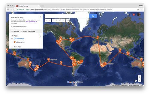
Over the next few posts I'm going to talk about the process I went through to integrate the itinerary for our imminent round-the-world trip into the awesome web-site my wife has set up. The initial approach I took was to use Google My Maps: this is a really cool tool for creating a custom map without any coding needed (yes, I know – that doesn't sound like much fun :-). For instance, you can set up your placemarks and link them with a route, and when individual places are clicked it shows a nice sliding info panel. I started out…
-
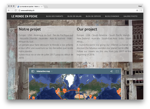
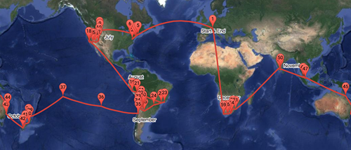
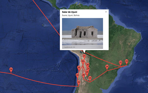
It's now less than a week before my family and I get on a plane and start our big trip: visiting 13 countries on 5 continents (not including the one we're starting from) over the course of 6 months. We leave on July 2nd, 2017, and – if our plans don't change – will return home on January 5th, 2018. Here's a map of where we're going… be sure to zoom into different locations and click on the place-markers to bring up additional information. It's been a deliberate choice, over the years, not to talk much about my family on…
-
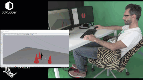
I mentioned this device, late last year, and have been meaning to spend time integrating it into AutoCAD ever since. The 3dRudder is an interesting perpheral: while currently targeted at helping seated VR users navigate intuitively in 3D – effectively keeping their hands free – it was originally intended for CAD users. So it's nice that it's going back to its roots, as it were. Here's an excerpt of a video of Christian Slater demoing the 3dRudder integration with Rhino (I'm kidding about it being Christian Slater – he just looks a bit like him :-). Over the last few…
-
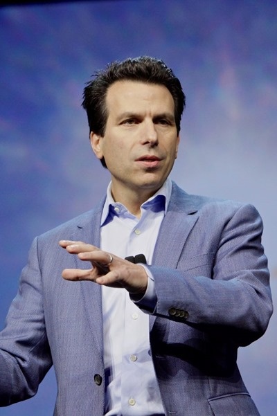
As John Walker once said, many years ago, Autodesk does not change CEO very often: during the first decade of the company's history, only two people had the role. Like a lot of things John said back then, it turned out to be impressively predictive of the future: during the following 25 years we had just two more! Here's the list: John Walker, 1982-1986 Al Green, 1986-1992 Carol Bartz, 1992-2006 Carl Bass, 2006-2017 Andrew Anagnost, 2017-… As you can see from the last item, the search for our new CEO has ended: after some months during which Andrew and Amar…
-

For most of the week – while at the Forge Accelerator in Barcelona – I sat next to an acquaintance (I'm happy to now call a friend) from Amazon Web Services: Tom "Elvis" Jones. Tom is a solution architect at AWS and has been to a number of Forge-related events over the last year or so. Autodesk has tightened its relationship with AWS in recent years, one of the reasons for Tom's presence at Forge events. From talking to Tom, it's clear he's interested in helping Forge developers get started more quickly with the AWS platform, something that's going to…